Enrique Frías-Martinez from Telefónica I+D talks about how cell phone networks could help in the future to modeling urban infrastructures
With the increasing capabilities of mobile devices, individuals leave behind footprints of their interaction with the urban environment. As a result, new research areas, such as urban computing and smart cities, focus on improving the quality of life in an urban environment by understanding city dynamics. Traditionally, urban analysis has used data obtained from surveys. However, new data sources (including GPS, Wi-Fi hotspots, geo-tagged social networks, etc.) are becoming more relevant as traditional techniques face important limitations, mainly: (1) the complexity and cost of capturing survey data; (2) the fact that the data is static and represents a snapshot of the situation in a specific moment in time and (3) the increasing unwillingness of individuals to provide (what they perceived to be) personal information. One of the main new data sources relevant for the study of urban environments are cell phone records, as they contain a wide range of human dynamics information (ranging from mobility, to social context and social networks) that can be used to characterize individuals or geographical areas.
In Telefónica I+D we have been working in three applications that use the data provided by a cell phone network infrastructure to demonstrate how the information extracted can be used to model city dynamics: Detection of Dense Areas (Hotspots), Land Use Identification (i.e., residential, industrial, commercial, etc.) and the Construction of Commuting Matrices.


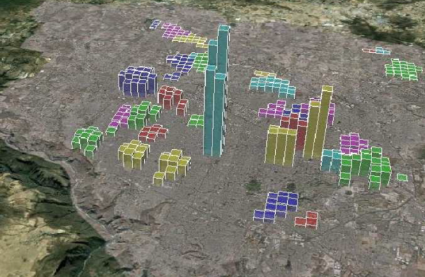
The detection of dense areas implies the identification of areas within an urban environment where people tend to go at specific moments during each day and their evolution over time. This information is of paramount importance for, among others, urban and transport planners as it provides key insights on where and when there are areas of high density of individuals in an urban environment. The problem of dense area detection was initially presented in the data mining community as the identification of the set(s) of regions from spatio-temporal data that satisfy a minimum density value. Common to all of these methods is that a fixed-size non-overlapping grid is used to aggregate the values. Therefore, these methods “constrain” the shape of the detected areas and, generally, identify dense areas that are a superset/subset of the desirable dense areas. At Telefónica I+D we have developed a new technique, the Dense Area Discovery (DAD-MST) algorithm (see details in reference [1]) to automatically detect dense areas using cell phone network data. Our approach, unlike the previous approaches, is not based on fixed-size grids, but on the natural tessellation of the spatial domain, thus overcoming the limitations of previous solutions. As an example, figure 1 presents the dense areas identified for the city of Guadalajara (Mexico).
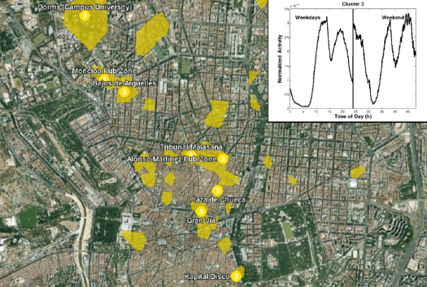
Using the information contained in a cell phone record database we can characterize the uses given to specific urban areas (such us residential, commercial, parks, etc.). The geographical areas in which the city is going to be divided will be defined by the approximated coverage of the set of communication towers. We define the activity of a communication tower, and by extension of its area of coverage, as the number of calls that are managed by that BTS over a given period of time, differentiating the activity during weekdays and during weekends. With this data, the identification of land uses can be automatically done by clustering the set of signatures using clustering techniques (such as k-means or spectral clustering). More details can be found in [2] and [3]. As an example, Figure 2, presents the night activity land use detected for Madrid, where it can be observed that the activity of this type of tower is characterized by a peak during weekend nights.
The spatio-temporal information contained in cell phone records can be aggregated to build a commuting matrix for an urban area. Such information is key for the design of transportation routes or to correlate the current transportation routes with the actual needs of the city in order to define new public transport routes. Formally the problem can be presented as the identification of frequent changes between two geographical areas at specific moments in time. At Telefónica I+D we have proposed a new algorithm (see reference [4] and [5]) for the construction of commuting matrices using cell phone records that we have validated with the commuting matrices generated by city-halls. Our results indicate that we can approximate the original matrix within a 15% error.
In conclusion, traditional urban analysis techniques are based on questionnaires which imply time and cost limitations. By extracting the knowledge generated by pervasive infrastructures, such as cell phone networks, we can generate models that explain urban dynamics and that complement traditional urban analysis approaches while overcoming the previous limitations. These examples are just intended as demonstrators of the capabilities of such approach, and can be used as building blocks to develop more specific applications.
References
[1] M. Vieira, V. Frias-Martinez, N. Oliver, E. Frias-Martinez, “Characterizing Dense Urban Áreas from Móbile Phone-Call Data: Discovery and Social Dynamics”, 2nd. Int. Conf. on Social Computing (SocialCom 2010), 2010.
[2] V. Soto and E. Frias-Martinez, “Robust Land Use Characterization of Urban Lanscapes using Cell Phone Data”, 1st Workshop on Pervasive Urban Applications, in conjunction with 9th Int. Conf. Pervasive Computing, San Francisco, 2011.
[3] V. Soto and E. Frias-Martinez, “Automated Land Use Identification using Cell-Phone Records”, ACM Hotplanet 2011, 3rd Int. Workshop on Hot Topics in Planet-Scale Measurement, co-located with ACM Mobisys 2011, Washington D.C.
[4] «Estimation of Urban Commuting Patterns Using Cellphone Network Data», V. Frias-Martinez, C. Soguero, E. Frias-Martinez, ACM SIGKDD Int. Workshop on Urban Computing (UrbComp), Beijin, China, 2012
[5] «An Agent-Based Model of Epidemic Spread using Human Mobility and Social Network Information», E. Frias-Martinez, G. Williamson, V. Frias-Martinez, The 3rd IEEE Int. Conf. on Social Computing (SocialCom 2011), Boston, MA, USA